AI Tool GOFlow Maps Ocean Currents in Unprecedented Detail
Key Points
- UC San Diego researchers introduced GOFlow, an AI system that maps ocean surface currents from thermal satellite images.
- Study published in Nature Geoscience on April 13 demonstrates higher resolution than traditional satellite and ship measurements.
- GOFlow was trained on simulated data, then applied to real satellite imagery to infer currents based on temperature changes.
- Validation against Gulf Stream ship data showed strong agreement and revealed finer-scale features.
- Cloud cover limits observations; team plans to incorporate additional satellite sources to mitigate gaps.
- Code will be released publicly to enable broader scientific use and further development.
- The advancement reflects a growing trend of AI enhancing Earth‑observation capabilities for climate and marine research.
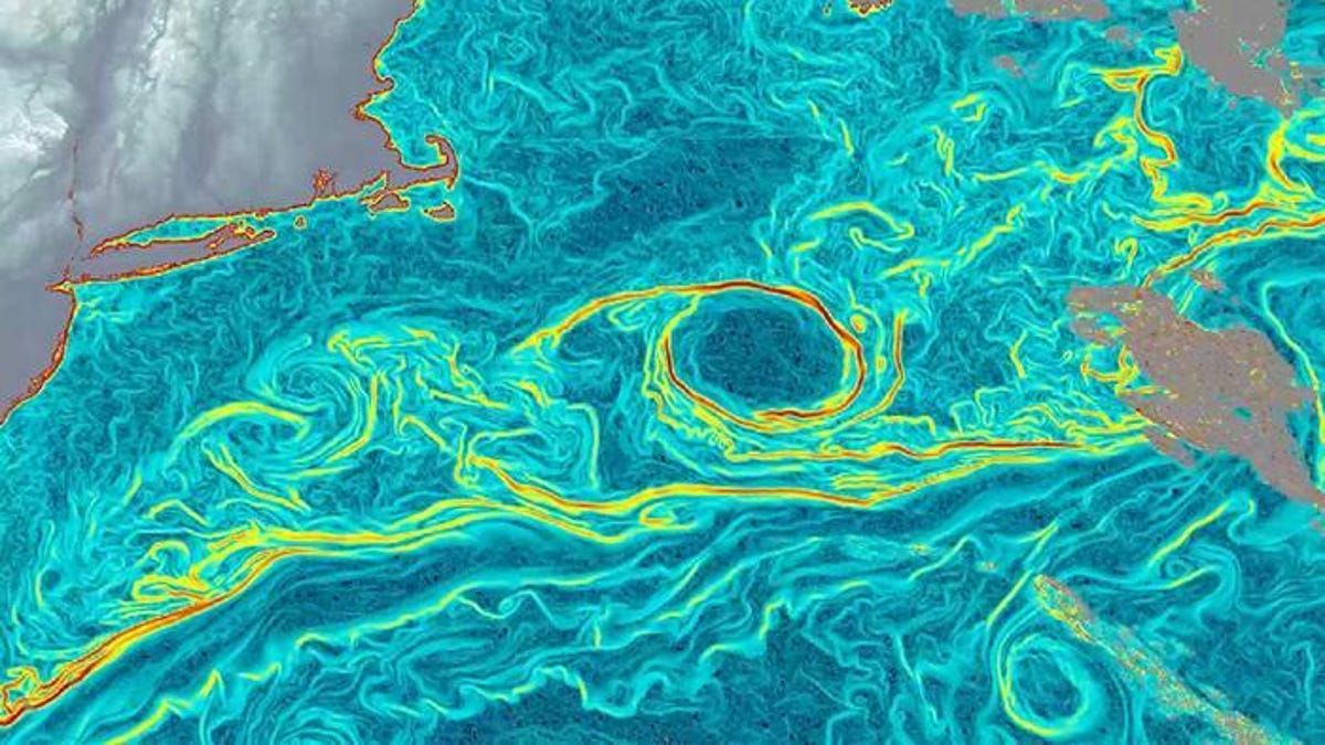
Researchers at the University of California, San Diego have unveiled GOFlow, an artificial‑intelligence system that extracts surface‑current information from thermal satellite imagery. Published in Nature Geoscience on April 13, the study shows the AI can track small, fast‑changing ocean currents with far greater resolution than traditional methods. By comparing GOFlow’s outputs to ship‑based measurements and conventional satellite data, the team demonstrated its accuracy while highlighting limitations such as cloud cover. The code will be released publicly, promising broader use of AI in Earth observation and climate research.
Scientists at UC San Diego’s Scripps Institution of Oceanography have taken a major step toward more detailed ocean monitoring. Their new artificial‑intelligence system, called GOFlow (Geostationary Ocean Flow), translates thermal images from weather satellites into high‑resolution maps of surface currents. The work, featured in the April 13 issue of Nature Geoscience, marks the first time researchers have been able to observe small, rapidly shifting currents from space with the level of detail previously limited to computer models.
Lead author Luc Lenain, an oceanographer at Scripps, described the breakthrough as a way to “extract physical information that is already present in satellite observations, but has been difficult to recover with traditional methods.” The team trained GOFlow on simulated ocean‑flow data before applying it to real‑world thermal imagery. By tracking temperature variations that arise as water moves, the AI inferred the underlying currents.
To validate the approach, the researchers compared GOFlow’s results with measurements collected by research vessels traversing the Gulf Stream. They also benchmarked the AI against conventional satellite techniques that rely on sea‑surface height anomalies. The comparisons showed strong agreement, but GOFlow delivered finer spatial detail, revealing micro‑eddies and transient features that older methods missed.
“We can now observe small, fast‑changing ocean currents from space with much greater detail and frequency than before,” Lenain said in an interview. He added that these currents play a critical role in transporting heat, carbon, nutrients and pollutants, making their accurate mapping essential for climate models, marine ecosystems and even commercial shipping routes.
Despite its promise, GOFlow faces practical challenges. Cloud cover can obscure the satellite’s view, preventing the AI from extracting temperature data on overcast days. The researchers plan to integrate additional satellite sources to fill these gaps, aiming for a more continuous global picture.
Transparency is a core tenet of the project. The team will release the GOFlow code openly, inviting other scientists to build upon the platform. Lenain emphasized the goal of “making this work transparent, reproducible and useful to the broader community.” He sees the system as a stepping stone toward routine use of massive remote‑sensing datasets combined with machine learning.
The development of GOFlow fits into a broader wave of AI applications in Earth observation. Agencies such as NASA and the European Space Agency, along with private space firms, are exploring similar tools to speed up data analysis and improve accuracy. As these technologies mature, they could reshape how governments, insurers, farmers and other stakeholders rely on satellite‑derived information for decision‑making.